Tuesday Evening Update on Hurricane Isaac (10 p.m.)
Isaac officially became a hurricane today and has since made its first landfall in southeast Louisiana as an 80 mph hurricane. The storm however is once again over open waters as it moves northwest at 8 mph according to the 11 pm EST advisory. Concerning the updated thoughts on our concerns here in south-central Kentucky, forecast models have come into an agreement that the storm will not take the eastern path that was indicated as a possibility yesterday and thus impacts in Warren Co should not be major. The current expected track would take the remnant storm well to our west in western Arkansas and Missouri with a turn northeast through Illinois and Indiana.
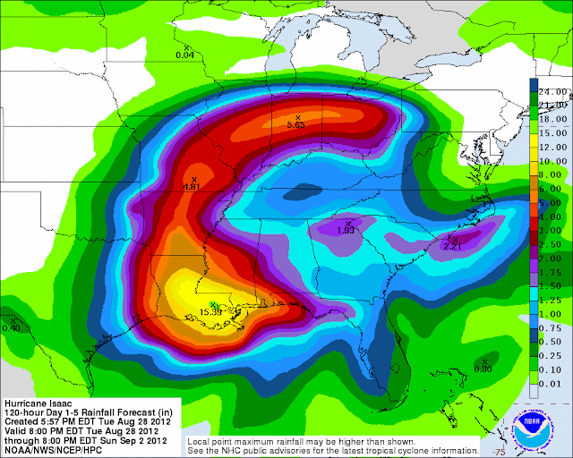
 If this path verifies, though impacts will be minimal, increased chances for rain can be expected into the weekend. The current Hydrometeological Prediction Center's 1-5 day rainfall predicts Isaac's heaviest rainfall along and just to the east of the expected path with about half inch to 1 inch predicted in our area.
----------------------------------------
It’s has been warm and dry the past couple of days here in Warren Co as students move back in on the hill. Today does bring a chance of a few showers however as a cold front slowly drifts into the area. Rain chances are fairly low and showers should be scattered in nature.
Isaac officially became a hurricane today and has since made its first landfall in southeast Louisiana as an 80 mph hurricane. The storm however is once again over open waters as it moves northwest at 8 mph according to the 11 pm EST advisory. Concerning the updated thoughts on our concerns here in south-central Kentucky, forecast models have come into an agreement that the storm will not take the eastern path that was indicated as a possibility yesterday and thus impacts in Warren Co should not be major. The current expected track would take the remnant storm well to our west in western Arkansas and Missouri with a turn northeast through Illinois and Indiana.

----------------------------------------
It’s has been warm and dry the past couple of days here in Warren Co as students move back in on the hill. Today does bring a chance of a few showers however as a cold front slowly drifts into the area. Rain chances are fairly low and showers should be scattered in nature.
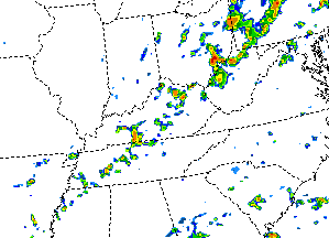 |
| Simulated Reflectivity from the 00z WRF model indicate scattered showers near Warren Co at about 6 pm this afternoon. |
Temperatures will be slightly cooler by
Tuesday and Wednesday with partly to mostly sunny skies. The big weather question of the week is that
of where Tropical Storm (soon to be Hurricane) Isaac will make landfall and move inland? Furthermore, will
its inland movement impact us here in Warren Co? The problem is that this question is very
difficult to answer due to the complexity of the situation and the way in which
the forecast models are handling it. To
this point the forecast models have been very unreliable from run-to-run and
have been consistently shifting the forecast track for Isaac further west. As the situation stands now (stay tuned to
the blog for further updates) some of the models bring the tropical system into
central-southern Louisiana and move it inland into Oklahoma/Arkansas before a
turn to the east and northeast. If this
situation were to unfold we here in Warren Co could possibly see the slight impacts
by the weekend though the worst of the system would past to our west and north. Other models bring the hurricane onshore near
Biloxi, MS and eventually bring it inland into western Tennessee and
just west of us. Should this occur our
impacts would be much greater from Isaac this weekend, with heavy rains
possible.
 |
| The official forecast track/intensity map from the National Hurricane Center as of 7 a.m. CST Monday. |
The official forecast from the
National Hurricane Center (www.nhc.noaa.gov) takes the system in the middle of the road so to
speak of the models with Bowling Green on the outer edge of the “cone of
uncertainty.” The major differences
surrounding the models concern interactions with a ridge in the plains and
trough in the east and the steering impacts they will have on the tropical
system. The bottom line is that the
remnants of Isaac have the POTENTIAL to impact us here in Warren Co this
weekend as thus changes in the forecast track need to be monitored
closely. While you’re keeping an eye on
Isaac enjoy an overall quite start to the week.
Daily Forecasts:
Monday: Partly cloudy skies in the morning should
become mostly cloudy by the afternoon and overnight with a 30% chance of a few
showers. High near 92. Winds will switch from the southwest (morning)
to the northwest (evening) and will be from 5-10 mph.
Tuesday: Decreasing clouds in the morning will make
for a partly to mostly sunny day with a morning low around 68 and a high near
88. Winds will be light from the north.
Wednesday: Sunny skies with a cool morning low near
59 and a high near 88. North winds a 5-10 mph.
Thursday: Partly to mostly sunny with a low near 61
and a high near 87.
No comments:
Post a Comment
Note: Only a member of this blog may post a comment.