A
Winter Storm Watch has been issued for Warren County by the NWS in Louisville for possible ice accumulations Friday afternoon/evening. The watch is in effect from midnight tonight until midnight Friday night. This watch will likely be updated to a warning or more likely some sort of winter weather or freezing rain advisory sometime this evening.
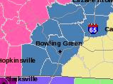 |
| Current watches and warnings as of 3:30 pm Central. Pink counties to the west indicate Winter Storm Warnings where accumulations could be significant. Warren County and Bowling Green are under a Winter Storm Watch. |
Discussion: A large winter storm system is currently intensifying across the southern plains which will push east in the next 24-36 hours providing a large amount of precipitation in various precipitation types across south-central Kentucky. First, rain which could be heavy at times will fall in this afternoon, overnight, and into tomorrow morning. An additional 0.75 to 1.5 inches of rainfall on top of the 0.64 inches of rain which fell this morning in Bowling Green is possible. Some minor flooding is possible by morning in areas that are flood prone. Meanwhile, temperatures will be chilly throughout the rain event. Temperatures in Bowling Green are currently in the mid 40s and dropping. Temperatures are expected to fall into the upper to mid 30s by this evening and remain steady in the mid 30s until early Friday afternoon. Thus there is little to no concern for freezing precipitation in Warren County overnight Thursday despite the cooling temperatures. However, by tomorrow midday temperatures could be at or near freezing across northwestern Warren County at which point freezing rain becomes a concern. Near Bowling Green, temperatures should remain above freezing through at least 3 pm and thus precipitation will remain rain until that time. It is between 3 pm and 6 pm when temperatures are expected to fall below freezing. With rain still expected to be falling, rain will freeze on contact thus creating ice accumulations. There remains some weather forecasting data discrepancy in how much precipitation will linger in Warren County/Bowling Green in the form of freezing rain. At this time, the data seems to be tending to allow precipitation to exit faster than at one time expected. If this is indeed the case, lesser ice accretions can be expected. Based on this data, current thinking is that up to a 10th of an inch can be expected in Bowling Green and points south and west. Areas across northwestern Warren County (near Hadley) can expect between a 0.10-0.25 inches of ice because temperatures will fall more quickly in these locations. Freezing rain is expected to end between 7 pm and 9 pm though light freezing drizzle is possible through midnight Friday night. Little to no sleet or snow is expected in Warren County. Below is a timeline of expected precipitation type and amounts.
Note that temperatures will struggle to warm on Saturday beneath mostly cloudy skies. Highs Saturday will only be around 34. By Saturday night, temperatures drop below freezing and precipitation again moves in. Freezing rain will likely fall with accumulating ice expected. More updates on this 2nd round of ice will be forthcoming.
 |
| Outline of potential ice timeframe and accumulations for Warren County. The pink line denotes the separation between the times and amounts. |
Now-Noon Friday: Rain which could be heavy at times. 0.50-1.25 inches of additional rainfall is expected. Some minor flooding is possible in flood prone areas. Temperatures will fall from the mid 40s to the mid 30s. Temperatures will hover in the mid 30s for most of this time frame.
Noon Friday-3 pm: Temperatures will be at or near freezing near in the northwestern part of Warren County and thus a change to freezing rain is possible during this time frame. Bowling Green will remain in the mid 30s through at least 3 pm thus precipitation is expected to remain rain. Up to a 0.10 of ice in the northwest Warren County with 0.10-0.25" of additional rain in the remaining part of the county.
3 pm - 9 pm: Temperatures will fall to or below freezing in Bowling Green and much of Warren County by between 3 pm and 6 pm and thus rain will become freezing rain. Ice accumulations county wide will be up to an additional 0.10" with areas further north and west favored for ice accumulations.
9 pm - Midnight Friday Night: Temperatures will fall into the upper 20s and precipitation will tapper off. Freezing drizzle is a concern and roads could be hazardous by this time.
After Midnight: Precipitation should end though skies will remain cloudy into Saturday morning and temperatures will drop to the low 20s.
Saturday: Mostly cloudy to cloudy skies with a high near 34.
Saturday Night: Lows in the mid 20s with a 70% chance of sleet and freezing rain.
Sunday: 70% chance of freezing rain early becoming rain during the day as temperatures moderate into the upper 30s.
Sunday Night: 30% chance of precipitation early. Otherwise cloudy and cold with temperatures dipping into 20s.
Forecaster: Ryan Difani


No comments:
Post a Comment
Note: Only a member of this blog may post a comment.