Good Sunday afternoon everyone! Hope you all had a restful weekend so now let's dive into some weird wild weather moving into our area in the next few days. Generally quiet in the upper atmosphere with a trough located to our northwest. A weak cold front will be making its way through this afternoon which will provide us with clouds and slightly cooler temperatures. Out in the western half of the United States a split flow is dominating from the Four Corners region to Arkansas and Missouri. A cutoff low is also taking shape in California and will reabsorb back into the jet later in the week which will be the big weather maker for us this week.
 |
| 300mb GFS model map valid for 12z for Thursday at 1:00 PM. |
Chances for rain will increase around Thursday and here is why. Notice the image above. The cutoff is moving to the northwest, and beginning to be reabsorbed into the jet. Vorticity values look limited at the 500mb level but plenty of moisture will be moving into the area on Wednesday with this storm. Winds coming from the south will help bring in the Gulf air at the 700mb level (shown below). This will keep us mostly cloudy on Wednesday, and on Thursday which is when this system will move in.
 |
| 700mb Moisture map valid for 12z for Thursday at 1:00 PM. |
Rain will begin Wednesday night and early Thursday morning. Precipitation will increase throughout Thursday, and finally push out Friday morning. Temperatures will be surging next week around this time. Expect highs into the 60s on Thursday, Friday, and Saturday. Strong temperature gradients on Thursday will keep our chance for thunderstorms in the forecast. No severe weather is expected though.
 |
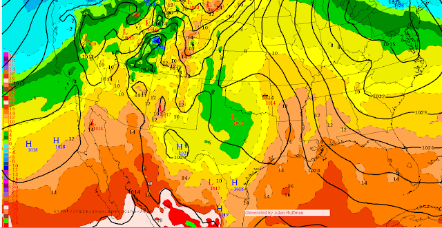
| ECMWF 12z, 850mb temperatures and heights on Friday. |
The European weather model, shown above, is in agreement that warm air is coming in but does show a lag in the low pressure moving through. This map shows 850mb temps, and heights.
So to recap, expect cool temperatures tomorrow and then a steady warm up through next week. Rain moving in late Wednesday night and pushing out Friday morning. Temperatures next weekend could get up to the mid 60s.
Monday: High 43 Low 21, Sunny skies
Tuesday: High 52 Low 26, Sunny skies
Wednesday: High 53 Low 46, Skies becoming cloudy
Look for another update tomorrow with a better idea of precipitation amounts for this storm and a discussion of our winter weather chances!
Forecaster: Brian Urbancic


No comments:
Post a Comment
Note: Only a member of this blog may post a comment.